


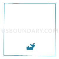
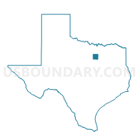
Voting District 1244, Tarrant County, Texas
About
Outline

Summary
| Unique Area Identifier | 677330 |
| Name | Voting District 1244 |
| County | Tarrant County |
| State | Texas |
| Area (square miles) | 8.15 |
| Land Area (square miles) | 8.13 |
| Water Area (square miles) | 0.03 |
| % of Land Area | 99.65 |
| % of Water Area | 0.35 |
| Latitude of the Internal Point | 32.62005830 |
| Longtitude of the Internal Point | -97.27493380 |
Maps

Graphs
Select a template below for downloading or customizing gragh for Voting District 1244, Tarrant County, Texas


Neighbors
Neighoring Voting District (by Name) Neighboring Voting District on the Map
- Voting District 1024, Tarrant County, TX
- Voting District 1025, Tarrant County, TX
- Voting District 1034, Tarrant County, TX
- Voting District 1153, Tarrant County, TX
- Voting District 1291, Tarrant County, TX
- Voting District 1295, Tarrant County, TX
- Voting District 1301, Tarrant County, TX
- Voting District 1378, Tarrant County, TX
- Voting District 1504, Tarrant County, TX
- Voting District 1642, Tarrant County, TX
- Voting District 2029, Tarrant County, TX
- Voting District 2262, Tarrant County, TX
Top 10 Neighboring County Subdivision (by Population) Neighboring County Subdivision on the Map
Top 10 Neighboring Place (by Population) Neighboring Place on the Map
- Fort Worth city, TX (741,206)
- Rendon CDP, TX (12,552)
- Forest Hill city, TX (12,355)
- Kennedale city, TX (6,763)
- Everman city, TX (6,108)
Top 10 Neighboring Unified School District (by Population) Neighboring Unified School District on the Map
- Fort Worth Independent School District, TX (466,910)
- Crowley Independent School District, TX (86,222)
- Burleson Independent School District, TX (52,131)
- Everman Independent School District, TX (22,395)
- Kennedale Independent School District, TX (17,898)
Top 10 Neighboring State Legislative District Lower Chamber (by Population) Neighboring State Legislative District Lower Chamber on the Map
Top 10 Neighboring State Legislative District Upper Chamber (by Population) Neighboring State Legislative District Upper Chamber on the Map
Top 10 Neighboring 111th Congressional District (by Population) Neighboring 111th Congressional District on the Map
Top 10 Neighboring Census Tract (by Population) Neighboring Census Tract on the Map
- Census Tract 1113.01, Tarrant County, TX (9,405)
- Census Tract 1110.05, Tarrant County, TX (9,204)
- Census Tract 1110.13, Tarrant County, TX (7,863)
- Census Tract 1112.02, Tarrant County, TX (6,095)
- Census Tract 1111.02, Tarrant County, TX (5,697)
- Census Tract 1112.03, Tarrant County, TX (5,564)
- Census Tract 1060.04, Tarrant County, TX (5,273)
- Census Tract 1060.02, Tarrant County, TX (3,463)
- Census Tract 1114.05, Tarrant County, TX (2,356)